Content
Use of AI-based image and video analysis software to automatically detect and count visitors from camera data, supporting continuous and non-intrusive monitoring of visitor numbers and flows in protected areas.
Classification
Key characteristics
Tool description
Constraints
- Requires advanced technical expertise for system setup, model configuration and training.
- Performance depends on image quality, lighting conditions, and camera positioning.
- Large amount of collected data, requiring adequate memory storage and/or data retrieval options.
- Potential biases related to algorithm training data (e.g. vehicles recognition).
- Privacy and data protection constraints may limit deployment and data storage.
Requirements
- Fixed or mobile cameras with suitable resolution and field of view
- AI software trained or configurable for outdoor and natural environments
- Computing infrastructure for data processing (local or cloud-based)
Tool Impact
Best Practices
-
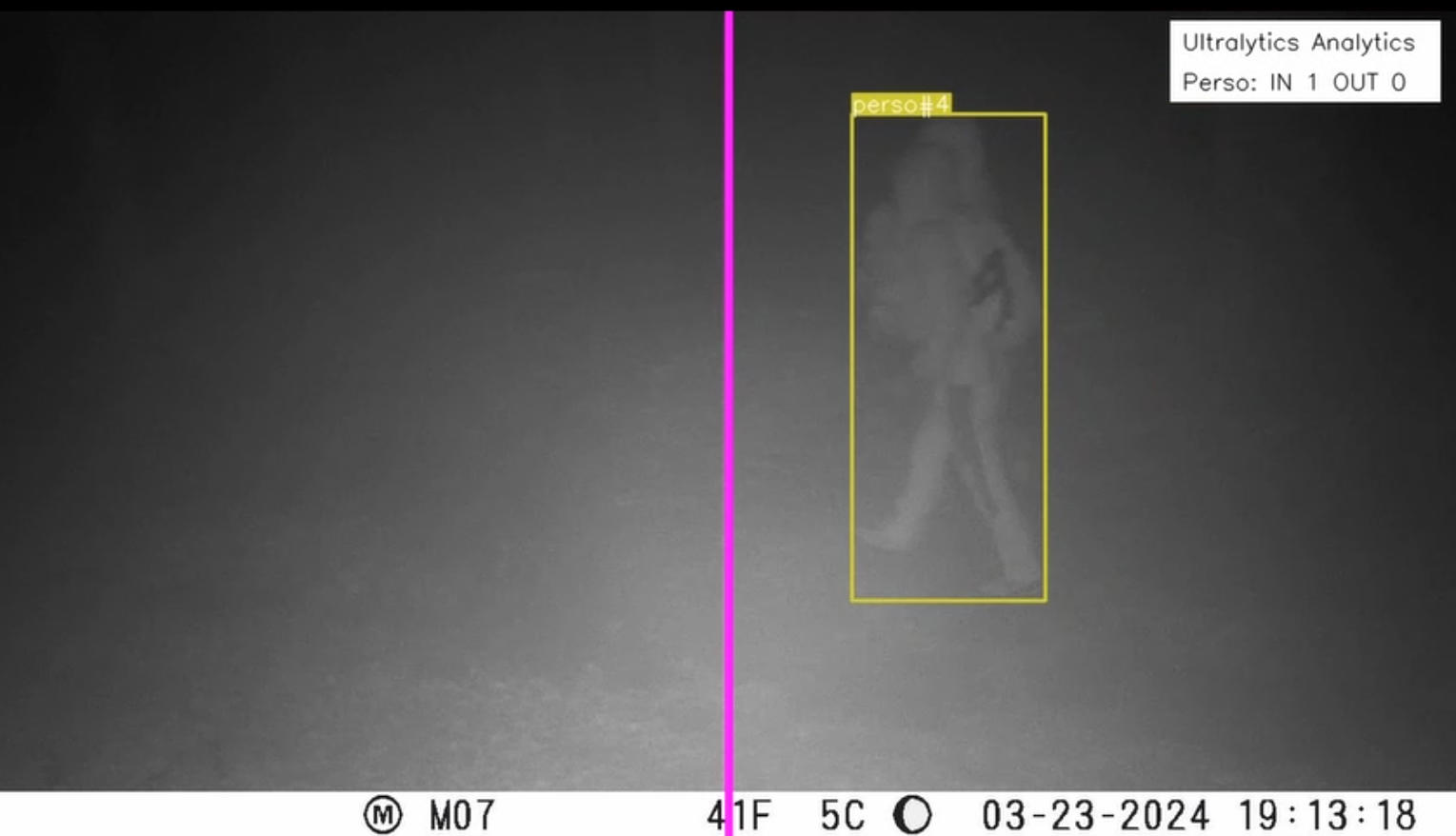
It is important to address both the classification and counting stages: the tested configuration within Interreg CE HUMANITA uses a YOLOv11-based object detection model for the identification and classification of visitors and vehicles, combined with a custom algorithm implementing a virtual “gate” positioned at the center of the camera field of view to count objects crossing the predefined line. Different models could be implemented according to specific needs, as well as the selection of the most appropriate format (photo, video) for the analysis.
Helpful hints to use the tool proficiently
- Carefully plan camera placement to ensure adequate coverage while minimizing the capture of identifiable personal features. Related to this, consider the implementation of additional algorithms to anonymize the subjects (e.g., pixelation).
- Verify in advance which elements the AI model is able to recognize and classify (e.g. pedestrians, bicycles, cars, other vehicles) and assess their relevance for the monitoring objectives.
- Pay particular attention to data retrieval and management, considering automated data transfer solutions due to the large volume of photo and video data collected. For the same reason, especially in case of camera traps usage, verify the possibility of adapting the quality and duration of the acquisition process to optimize the tool efficiency.
Specification
| Category | Software |
| Platform |
Desktop
|
| Operating system |
OS-independent
|
| Mode | Only offline |
Linked tools
| Category | Tool title and description |
Study object
|
Study focus
|
Work step
|
Tool purpose
|
Classic | Professional | Free to use | Experimental |
|
Automatic visitor counters
Automated sensor-based systems for quantifying visitor numbers and analyzing temporal and spatial visitation patterns in natural areas. |
|
|
|||||||
|
Camera traps for visitor monitoring
Passive recording of human presence along trails and access points using motion-triggered camera traps. |
|
|
|||||||
|
GPS Loggers for visitor monitoring
Portable devices used to record visitor movement patterns, routes, speed, and stay times, providing spatially explicit data to better understand visitor flows and site use. |
|
|
|||||||
|
MegaDetector Video Counting
Adapted MegaDetector algorithm (AI model that identifies animals, people and vehicles in camara trap images) to count animals, people and vehicles in short videos. |
|
|
|||||||
|
Mobile phone network data for visitor monitoring
Use of anonymized and aggregated mobile network event data to estimate visitor numbers and origin areas for selected protected areas and surrounding regions. |
|
|