Content
Analysis of outdoor app data (.gpx and metadata) to understand spatial distribution of digital trails and estimated usage of trails.
Classification
Key characteristics
Tool description
Constraints
- Non-representative user base – Data reflect only users of specific apps and digitally active visitor groups.
- Platform-specific bias – Different apps attract different user profiles (e.g. hikers, cyclists, mountain bikers).
- Algorithm influence – Automatically suggested tours may amplify already popular routes.
- Dynamic content – Tours and metadata change frequently, affecting reproducibility over time.
- Incomplete or inaccurate information – User-uploaded routes may contain GPS errors or outdated information.
- No direct visitor counts – Promoted tours do not equal actual on-site use.
- Access limitations – Full metadata often require paid or pro accounts.
- Legal and ethical considerations – Use of scraped or downloaded data must comply with platform terms of service.
Requirements
- Pro or institutional accounts for selected outdoor apps
- GIS software and technical expertise for spatial data integration and analysis
- Standardized workflow for downloading, cleaning, and updating tour datasets
- Capacity to manage and interpret metadata indicators (views, downloads, ratings)
- Clear documentation of assumptions and weighting schemes
- Calibration with on-site monitoring tools (counters, surveys)
- Regular monitoring intervals to track content changes over time
- Privacy compliant data handling
Tool Impact
Best Practices
-
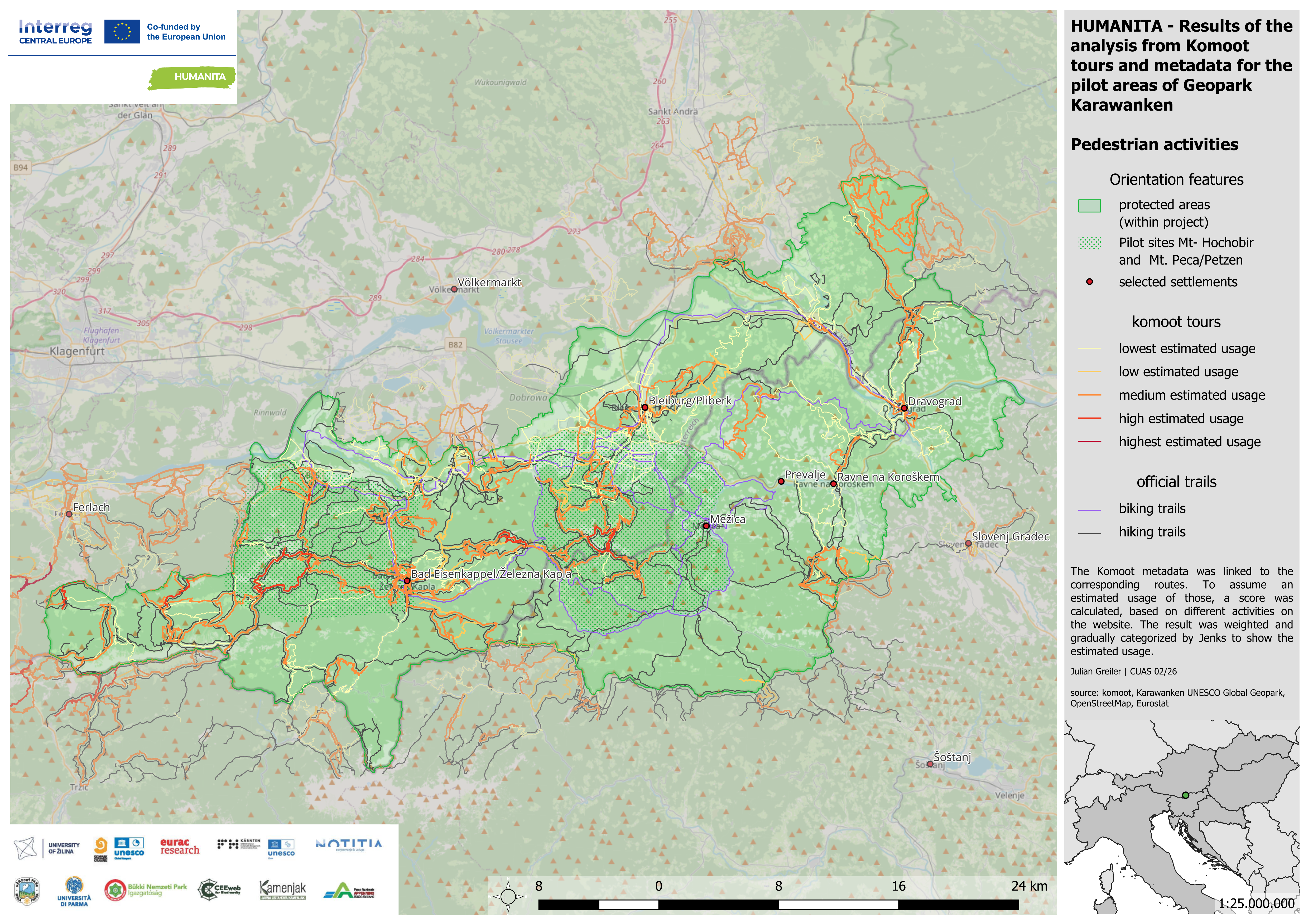
Within the Interreg Central Europe project HUMANITA, data from the outdoor and fitness apps Bergfex, Komoot, Outdooractive, Trailforks, and Strava were analyzed to estimate spatial hotspots and low-use areas in pilot regions. The objective was to identify officially promoted and unofficial user-generated activities that may indicate recreational trends, development potential, or conflicts within protected areas. Tour data were systematically organized and integrated into a GIS project. This enabled protected area managers to detect clusters of digitally promoted routes, identify potentially problematic trails in sensitive zones, and proactively manage online content where necessary. The analysis provided strategic insights into how digital platforms shape visitor distribution and perception of landscapes.
Helpful hints to use the tool proficiently
- Define clear spatial boundaries (polygons) that match management-relevant units before downloading data.
- Regularly monitor and update datasets, as digital content changes frequently.
- Use a standardized Tour Score approach to estimate relative promotion intensity across tours.
- Clearly document and justify any weighting schemes applied to metadata indicators.
- Compare multiple platforms to reduce single-platform bias.
- Combine digital promotion data with field-based monitoring tools for calibration.
- Identify and review tours crossing sensitive or restricted areas, and engage with platform providers if needed.
- Communicate uncertainties and sampling bias transparently to stakeholders.
- Consider assigning a staff member or “digital ranger” to oversee online content management.
Specification
| Category | Software |
| Platform |
Portable
Web
|
| Operating system |
OS-independent
|
| Mode | Both online and offline |
Linked tools
| Category | Tool title and description |
Study object
|
Study focus
|
Work step
|
Tool purpose
|
Classic | Professional | Free to use | Experimental |
|
Automatic visitor counters
Automated sensor-based systems for quantifying visitor numbers and analyzing temporal and spatial visitation patterns in natural areas. |
|
|
|||||||
|
GPS Loggers for visitor monitoring
Portable devices used to record visitor movement patterns, routes, speed, and stay times, providing spatially explicit data to better understand visitor flows and site use. |
|
|
|||||||
|
Mobile phone network data for visitor monitoring
Use of anonymized and aggregated mobile network event data to estimate visitor numbers and origin areas for selected protected areas and surrounding regions. |
|
|
|||||||
|
Strava Metro
Strava Metro is a data service provided by Strava that uses aggregated and anonymized activity data (e.g. walking, running, cycling) from users of the Strava app to analyze movement patterns. |
|
|