Content
UAV-based LiDAR scanning for erosion monitoring enables detailed, high-resolution mapping of terrain changes over time. It allows accurate detection and quantification of erosion processes across large areas without the need for extensive field surveys.
Classification
Key characteristics
Tool description
Constraints
- Requires specialized equipment and trained personnel, which can lead to increased operational costs.
- Flight time and spatial coverage are limited by UAV battery capacity and weather conditions, particularly strong wind, rain, or fog.
- Dense vegetation can partially obstruct laser penetration to the ground in forested areas.
- Regulatory restrictions on UAV flights, especially in protected areas, may limit data collection.
- Data processing and analysis are technically demanding and time-consuming, requiring advanced software and expertise.
Requirements
- Access to a UAV platform equipped with a suitable LiDAR sensor and GNSS or IMU Positioning system to ensure high spatial accuracy
- Trained operators and pilots for flight planning, data acquisition, and compliance with aviation regulations
- Adequate software and computing capacity for data processing, calibration, and analysis of point clouds and digital elevation models
- Regular maintenance of the UAV and sensor, battery management, and calibration to ensure data quality and operational safety
- Legal permits and coordination with land managers or protected area authorities
Tool Impact
Best Practices
-
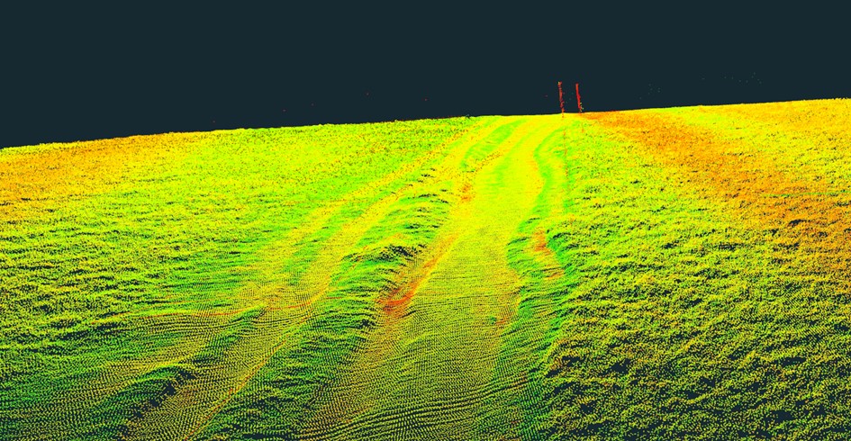
In the Interreg CE project HUMANITA erosion monitoring was carried out using repeated UAV-LiDAR acquisitions to improve understanding of digital elevation model uncertainties. The aim was to capture the terrain shape along selected hiking trail sections in Malá Fatra National Park (Slovakia) on specific dates, chosen to represent periods before and after the tourist season. Measurements were therefore conducted twice a year. Data was collected using LiDAR mounted on a UAV, with GNSS used for georeferencing the system and determining the UAV trajectory. The system captured the terrain geometry as a georeferenced point cloud. Collected data were post-processed following a pre-set methodology to produce high-quality, georeferenced, dense point clouds with real texture. LiDAR360 and Inertial Explorer were used for processing raw data into georeferenced point clouds. The resulting point clouds support vector and raster analyses to detect terrain changes and identify deformations caused by erosion. In addition, tourist counters were installed along the monitored trail sections to quantify visitor numbers. Combining LiDAR-derived terrain changes with visitor data enables estimation of the impact of tourist pressure on trail erosion. With point clouds from multiple epochs, spatially explicit topographic changes can be detected, including trail branching and the formation of new paths.
Helpful hints to use the tool proficiently
- Data acquisition processes need to be adapted to outdoor conditions such as temperature and rain or snow.
- The proper choice of timing and weather conditions is essential to ensure the required quality of the output data.
Specification
| Category | Device / Key |
| Properties |
Measurement device
Sensor
Small/light
Can be used in online/live mode
|
| Range |
ground
close range
airborne
medium range (several km)
local
multiple scale
|
Linked tools
| Category | Tool title and description |
Study object
|
Study focus
|
Work step
|
Tool purpose
|
Classic | Professional | Free to use | Experimental |
|
Backpack 360° panoramic camera for erosion monitoring
Mobile ground-based spherical imaging performed with a 360° photogrammetric sensor carried by an operator along a selected trail to map the terrain. |
|
|
|||||||
|
Backpack LiDAR scanner for erosion monitoring
Mobile ground-based LiDAR system for high-resolution 3D mapping of terrain and small-scale surface changes. |
|
|
|||||||
|
Onboard LiDAR sensor
Light Detection And Ranging (LiDAR) sensor to scan the environment. |
|
|
|||||||
|
UAV-based photogrammetry for erosion monitoring
Aerial photogrammetric survey aimed at determining soil erosion on existing trails and identifying unofficial paths due to trampling. |
|
|
|||||||
|
Unmanned aerial system (UAS)
UAS are flying devices that carry different camera or sensor types for aerial photographs and atmospheric measurements. |
|
|
Gallery
Images