Braun-Blanquet scale vegetation survey
Braun-Blanquet scale vegetation survey
Braun-Blanquet scale vegetation survey
Image source: Limanek © 2025 All rights reserved
Content
Plot-based, semi-quantitative vegetation survey method to assess plant species composition and cover.
Classification
10
9
Study object
Vegetation, Funghi & Lichen
Habitats
Indicators
Plants (incl. Algae)
Forest
Rocky
Grassland
Savanna
Desert
Wetlands
Shrubland
Funghi (incl. Lichen)
Other
Study focus
Anthropogenic factors and impacts
Biodiversity (Species populations and Community Composition)
Ecosystem State, Structure and Functioning
Precise focus
Species abundance
Species identification
Species disturbances (invasive species, etc.)
Land-use and Land-use change
Phenology
Community abundance
Habitat structure (vertical profile, vegetation cover, etc.)
Species diversity
Other biodiversity factors
Key characteristics
Work step
Data collection
Tool purpose
Numeric and Alphanumeric Data
Photo/Video Data
Spatial Data
Properties
Classic
Professional
Keywords
Standard
Terrestrial - aboveground
HUMANITA
Vegetation
Tool description
The Braun-Blanquet method is a standardized, plot-based vegetation survey approach used to describe plant communities and assess species composition, abundance, and vegetation structure. Surveys are conducted within clearly defined plots, where all plant species are recorded and assigned a cover-abundance value using the Braun-Blanquet scale (r, +, 1–5).
In addition to species presence and relative cover, the method can document vegetation layers, habitat characteristics, and phenological stages. The output consists primarily of numeric and alphanumeric data, which allow comparison across sites and monitoring periods.
The method is widely applied in biodiversity monitoring, habitat classification, conservation assessment, and long-term ecological studies, particularly where changes in species composition and vegetation structure need to be documented over time.
Constraints
- Semi-quantitative approach; cover values are based on expert estimation.
- Results are sensitive to plot size and location selection.
- Does not capture detailed demographic, genetic, or fine-scale spatial patterns.
- Requires strong botanical expertise for accurate identification.
- Seasonal timing influences species detectability.
Requirements
- Defined sampling plots and field survey equipment (measuring tape, plot markers, field sheets)
- Botanical expertise for accurate species identification
- Standardized application of the Braun-Blanquet cover scale
- Basic data management tools for data entry and archiving
- Optional photographic documentation for verification and comparison
Tool Impact
The Braun-Blanquet method has a very low environmental impact. Fieldwork involves only temporary access to survey plots and minor trampling within small, predefined areas. Occasional collection of plant specimens for identification purposes may occur but is typically limited and controlled. No permanent installations or habitat alterations are required. When conducted carefully, the method is suitable even in ecologically sensitive habitats.
Best Practices
-
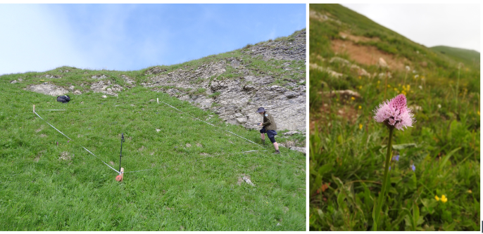
Within the Interreg CE project HUMANITA, botanical surveys using the Braun-Blanquet method were conducted in Malá Fatra National Park starting in June 2024, during peak alpine vegetation development. The objective was to document habitats of European and Slovak importance and identify protected and endangered plant species. Pilot sites were systematically surveyed, recording all observed species and assigning standardized cover values. Photographic documentation supported field records, and selected specimens were collected for further identification when necessary. Based on species composition, habitat types were classified for each site. The survey was repeated in 2025 to ensure comparability and enable detection of changes over time, supporting long-term habitat monitoring and conservation planning.
Helpful hints to use the tool proficiently
- Conduct surveys during peak vegetation development to maximize species detectability.
- Use clearly defined and permanently documented plot locations to ensure long-term comparability.
- Apply the Braun-Blanquet scale consistently among surveyors to reduce observer bias.
- Where possible, ensure the same trained botanists conduct repeated surveys.
- Take standardized photographs of each plot to support interpretation and future comparison.
- Carefully document habitat characteristics (slope, aspect, disturbance signs) alongside species data.
- Avoid surveying immediately after extreme weather events that may temporarily alter vegetation appearance.
- Store data in a structured database to enable long-term trend analysis.
- When uncertain about species identification, collect minimal specimens for office-based verification.
Specification
| Category | Manual / Guideline / Framework |
| Type |
field guideline
guideline
framework
methodology
|
| Range |
local
regional
|
Linked tools
| Category | Tool title and description |
Study object
|
Study focus
|
Work step
|
Tool purpose
|
Classic | Professional | Free to use | Experimental |
|
Field manual for rapid vegetation classification and survey for general purposes
Guideline for vegetation surveys and subsequent classification. |
|
|
|||||||
|
Field recording form
Standardized paper form for collecting monitoring data in the field. |
|
|
|||||||
|
Linear measurement equipment
Measuring equipment like a tape measure or ruler for measuring short distances (< 100 m). |
|
|
|||||||
|
plot marking material
Tools for highlighting the units being surveyed. |
|
|
|||||||
|
plot sampling
In ecology, plot sampling is a method for density, biomass, cover and frequency estimation of targeted organisms in which plots are selected from within a survey region and sampled. |
|
|
|||||||
|
Single-lens reflex (SLR) camera
Device for taking digital images in high resolution. |
|
|
|||||||
|
stakes and survey nails
Tool for fixing strings or marking study unit edges. |
|
|
Gallery
The gallery is empty.
Legend
Study objects
Microbiota
Humans
Animals
Vegetation, Funghi & Lichen
Habitats
Study focus
Anthropogenic factors and impacts
Biodiversity (Species populations and Community Composition)
Ecosystem State, Structure and Functioning
Work steps
Presentation
Data collection
Plot establishment
Data analysis
Data archiving
Tool categories
TBD
Device
Software
Manual / Guideline / Framework
Tool purposes
Spatial Data
Numeric and Alphanumeric Data
Audio Data
Genetic Data
Photo/Video Data
Non Data generative
Chemical Compound Data