Surface water quality monitoring
Surface water quality monitoring
Surface water quality monitoring
Image source: Bokuvka © 2025 All rights reserved
Content
Systematic monitoring of chemical, physical, and biological parameters to assess the ecological status of rivers and surface waters.
Classification
3
6
Study object
Habitats
Indicators
Wetlands
Lakes and Pools
Rivers, Streams and Creeks
Study focus
Anthropogenic factors and impacts
Biodiversity (Species populations and Community Composition)
Ecosystem State, Structure and Functioning
Precise focus
Species abundance
Species identification
Pollution
Species distributions
Water quality and composition
Species diversity
Key characteristics
Work step
Data collection
Data analysis
Tool purpose
Numeric and Alphanumeric Data
Photo/Video Data
Chemical Compound Data
Spatial Data
Properties
Classic
Professional
Keywords
Aquatic
HUMANITA
Pollution
River
Tool description
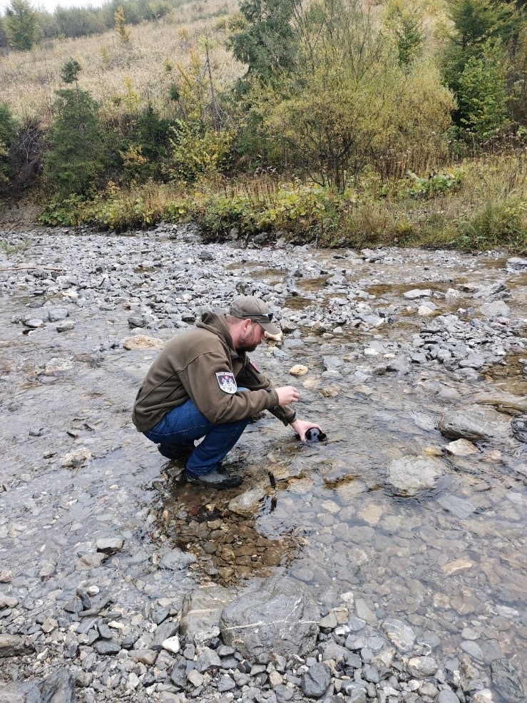
Surface water quality monitoring is a standardized environmental monitoring approach used to evaluate the chemical, physical, and biological condition of rivers and other surface waters. It provides essential information on ecosystem health and the influence of natural processes and human activities, including tourism, settlements, and land use.
Monitoring programs are designed to capture both spatial and temporal variability. Sampling sites are strategically selected to represent different river sections, upstream reference conditions, downstream impact zones, and potential pollution sources.
Standard parameters typically include physical indicators (e.g., temperature, turbidity, conductivity), chemical indicators (e.g., nutrients, organic pollution markers), and biological quality elements. Data are collected through field sampling, laboratory analyses, and in situ sensor measurements.
Surface water monitoring is a core component of integrated environmental management and supports sustainable water resource planning and impact assessment.
Constraints
- Limited spatial coverage depending on the number and placement of monitoring sites.
- Periodic sampling may miss short-term pollution events (e.g., storms, accidental discharges).
- Laboratory detection limits and sensor accuracy may restrict identification of very low pollutant concentrations.
- Results influenced by natural seasonal and hydrological variability, complicating interpretation.
- Access to remote or high-flow sites may be challenging during extreme weather conditions.
- Requires long-term datasets to distinguish trends from natural variability.
Requirements
- Clearly defined monitoring objectives and standardized protocols
- Representative selection of upstream reference and downstream impact sites
- Field equipment for sample collection and in situ measurements (sampling bottles, multiparameter probes, flow meters)
- Accredited laboratory facilities with validated analytical methods
- Quality assurance and quality control procedures
- Regular calibration and maintenance of sensors and equipment
- Data management and statistical analysis capacity
Tool Impact
Surface water quality monitoring has a generally low environmental impact, as it is primarily observational and minimally invasive. Sampling involves small water volumes and does not significantly alter aquatic habitats. Temporary disturbance may occur during field access to riverbanks, particularly in sensitive riparian zones, but this can be minimized through careful site selection and adherence to established access paths.
Best Practices
-
Within the Interreg CE project HUMANITA, surface water quality monitoring was conducted in the Varínka river basin (Vrátna Valley) and the Stohový stream flowing through the Štefanová settlement in Malá Fatra National Park (Slovakia). The objective was to assess whether tourism-related human activities influenced river water quality. Water samples were collected bi-weekly over one year (August 2024–August 2025) at four strategically selected sites: two upstream reference points representing near-natural baseline conditions and two downstream sites capturing potential cumulative impacts from the settlement and tributaries. Key physicochemical parameters linked to municipal wastewater and recreational pressure (COD, conductivity, ammonium, nitrates, phosphates, turbidity) were analyzed. The spatial comparison between reference and impacted sites enabled detection of pollution gradients, dilution effects, and seasonal variability associated with tourism intensity. The monitoring design proved replicable and suitable for identifying point-source pollution in sensitive protected areas, supporting evidence-based water management decisions.
Helpful hints to use the tool proficiently
- Include upstream reference sites to establish baseline conditions.
- Select downstream sites strategically to capture cumulative impacts from settlements or tributaries.
- Conduct monitoring over at least one full year to capture seasonal variability.
- Increase sampling frequency during peak tourist seasons or after heavy rainfall events.
- Record hydrological conditions (e.g., flow rate, recent precipitation) during sampling.
- Standardize sampling time of day to reduce variability.
- Ensure strict sample handling and transport protocols to maintain data quality.
- Document all procedures clearly to ensure replicability and long-term comparability.
- Interpret results cautiously in small streams where dilution effects may strongly influence concentrations.
Specification
| Category | Manual / Guideline / Framework |
| Type |
field guideline
methodology
|
| Range |
local
|
Linked tools
| Category | Tool title and description |
Study object
|
Study focus
|
Work step
|
Tool purpose
|
Classic | Professional | Free to use | Experimental |
|
Water-level logger
Device for continous measuring of water levels. |
|
|
Gallery
The gallery is empty.
Legend
Study objects
Microbiota
Humans
Animals
Vegetation, Funghi & Lichen
Habitats
Study focus
Anthropogenic factors and impacts
Biodiversity (Species populations and Community Composition)
Ecosystem State, Structure and Functioning
Work steps
Presentation
Data collection
Plot establishment
Data analysis
Data archiving
Tool categories
TBD
Device
Software
Manual / Guideline / Framework
Tool purposes
Spatial Data
Numeric and Alphanumeric Data
Audio Data
Genetic Data
Photo/Video Data
Non Data generative
Chemical Compound Data